The night at the tiny, tidy Fairbanks airport was rather restless; unfortunately they don’t turn the lights or the easy listening music off (Pure Shores by All Saints!!!), and I think my body was a little thrown off by how light it was outside. Â After flying to Prudhoe Bay, the sun wouldn’t set for several days, and the first four days of the journey seemed like one long drawn out encounter with gravel roads and mosquitoes.
I sat in the terminal waiting for the incoming flight from Anchorage to let some of its passengers off, and then a bunch of huge freight containers were loaded to the front half of the plane, a Boeing 737-400 Combi. Â I then boarded the plane and greeted Baptiste for the first time. Â I ended up with a seat behind him, so we weren’t able to converse too much. Â The plane was mostly full of tough looking guys in hats with oil company logos, and a few tourists.
I dozed in and out during the flight, and woke up as we were going over the pipeline as  we approached Deadhorse.  About half the passengers stayed on the plane, they were headed toward the end of the line, Barrow.
“]
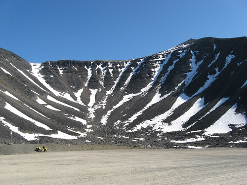
![Pipeline near Prudhoe Bay [Photo: Baptiste Poncet]](http://lh3.ggpht.com/_rIDV8qandOc/SlPG3OCrf2I/AAAAAAAAABw/TntVYB9qCP0/s400/imgp1289.jpg)
Pipeline near Prudhoe Bay (Photo: Baptiste Poncet)
After getting our bags and bikes, Baptiste and I sat around for about half an hour until the airport emptied out. Â Then began the task of putting out bikes back together. Â We had been given the OK to turn the baggage claim area into our workshop. Â The airport employee mentioned a few other bikers that had come through in the past weeks.

Deadhorse Baggage Claim (Photo: Baptiste Poncet)
I was anything but enthusiastic at this point; Â hungry and tired, without coffee, and wondering what I was doing here. Â It took almost 5 hours to get everything put together and packed up.

I donned my insulated calf-length biking shorts, expecting to be cold, but would soon realize they would be unnecessary for this part of the trip. Â We rolled out of the airport and saw a bit of the town, mostly warehouses, a lot of trucks, and headed to the general store to buy a few things. Â Everything there is super expensive, I’m glad I had bought all my food in Seattle.
The post office is in the same building, we went by and saw the billboard that has Polaroid shots of travellers, including lots of bicyclists I had read about before. Â The friendly postal worker there documents folks at the start or the finish of their trip.

Post Office worker and documenter of travellers (Photo: Bapstiste Poncet)

Berling brothers from pebblepedalers.com and Baptiste and I
(Side note: Â If you are starting your bike trip in Deadhorse, talk to the post office worker in the picture, she has become the keeper of partially full gallon containers of white camping gas. Â The general store does not sell a smaller size, so we had to leave the remainder of ours there)
We ate some lunch outside the store, and were on our way out of Deadhorse, passing some caribou. Â It was not long before the mosquitoes descended on us. Â This and the lack of sleep had me wanting to call it a day as soon as possible. Â I knew some sleep would mean a better attitude. Â After 20 miles, we pulled of to the side of the road and set up tent.

It is not easy eating through these headnets (Photo: Baptiste Poncet)

How many do you see? (Photo: Baptiste Poncet)
I would wake up rather rested, despite the sun being out the whole night. Â The first day was getting familiar with mosquitoes, the second I became familiar with riding on gravel.

Riding on gravel is really OK, you just go a couple miles an hour slower than you are used to. Â We had a nice tailwind, this meant that the mosquitoes had no problem keeping up with us. Â I tried wearing my rain jacket to prevent bites, but got way to hot. Â I resorted to the 99% DEET on my arms, back and hands, this seemed to work OK.
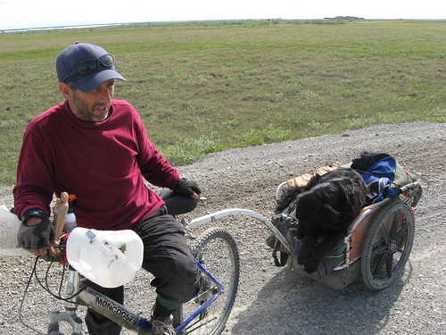
We came upon Joseph headed north on bicycle with his dog Star. Â He’s from Oregon and was riding from Fairbanks to Deadhorse. Â He warned us about the hills to come…
We met Frana, a young lady standing at the side of the road, asked her what she was doing there. Â Her dad and her had driven up from Fairbanks, parked the car, and were trying to get a ride 30 miles south to Happy Valley to launch their raft and make it back to their car in a few days. Â Later that day we made it to Happy Valley, an old workers camp, and saw that they had found a ride. Â We had gone 60 miles, and decided to call it a day, and camped by the river too.
As we ate dinner, we noticed another tent being set up, and realized it was another cyclist. Â We went over and met Thomas from Germany, who is not only biking the length of the Americas, but also climbing the highest peak of every country he visits. Â He had already climbed McKinley and Logan in Canada, and had started out in Deadhorse that day on a recumbent bike.
Another night with sun, but I rested just fine again. Â We would chat with Thomas again in the morning, but he got going a little while before we did.
We met Kenta sometime that day, he’s from Japan, studying in Washington. Â He’s biking around Alaska and is headed to Montana before taking the Amtrak back to Washington in the fall. Â Maybe I’ll run into him down the road.

Soon after meeting Kenta, I noticed a cyclist approaching from the north, and realized it was Thomas, somehow we had passed him, even though we hadn’t expected to see him again. Â He had pulled over at a pump station earlier and slept for a while as he was feeling under the weather.
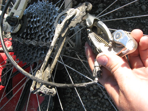
On our way up a hill, Baptiste’s back derailleur snapped off the frame… something that can’t be repaired on the road. Â The reality of the situation set in, and it was clear he would have to hitch a ride to Fairbanks and look for a repair. Â We said goodbye, and I was on my way.
I got to the top of the hill and found Thomas relaxing and taking in the amazing view. Â As we took in the scenery, we heard a honk and saw Baptiste waving from the cab of a truck with his bike strapped to the back, he had found a ride within half an hour. Â I would not see him till Fairbanks a week later.
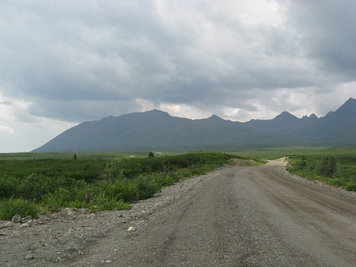
Thomas and I would stick together the rest of the day, and I probably biked a little further that I would if I was alone. Â I knew they next day was Atigun pass, and was happy to have gotten as close to it was we did. Â We were now encountering some serious hills, and could see the Brooks Range across the horizon.

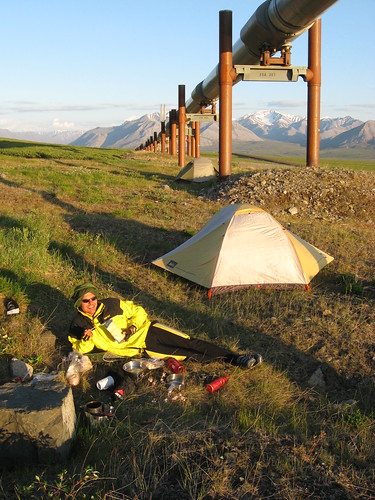
We made the decision to camp on the side of a big hill with a great view, it also happened that the pipeline was right there. Â We read the rather ambiguous warning sign and decided it didn’t really apply to people without vehicles. Â We enjoyed dinner and talked a little about the day ahead. Â He wanted to get all the way to Coldfoot, 100 miles, I would be happy to just get over the mountain pass.
Thomas said goodbye on his way out early the next morning and I decided to sleep in another few hours.  When I was packing up, an Alyeska security truck aproached and they asked me if I had spent the night there or not.  They told me that there was no camping on the right-of-way, which apparently includes everything in the vicinity of the pipeline, not just the access road that runs along the pipeline, which we had made sure not to block.  They mentioned something about getting a permit at the pump station (paperwork!?!?), but I didn’t quite understand what that would allow me to do.  At any rate, I made sure not to camp under the pipeline again, and am posting the pictures in good faith that I won’t be prosecuted, and to serve as a notice to other travellers of what not to do.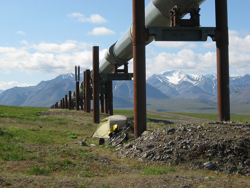
The next day brought longer slopes upward as I started to enter the narrow valley into the Brooks Range. Â All this by the way was incredibly beautiful.


Up until then I had only had walk my bike up a few short steep hills, but then I arrived at the bottom of the pass and realized that this would take me a while. Â Photos can’t really capture the road as it wound steeply around the side of the mountain.
I started to walk the bike up, and it took a grueling hour to make it to the top. Â This was my first mountain pass and it was rather underwhelming (not even a sign to take a picture in front of!), I wasn’t quite sure all the effort was worth it. I ate a celebratory meal, thinking the hard part was over. Â I hung around for a little, trying to rest a little.
I pedaled slowly downhill and soon had the feeling in my gut when you are at the top of a rollercoaster and have no control of the descent.  I started to gain speed and knew I would have to brake most of the way down.  The smell of my brakes became strong and I got a little worried.  The road started to look much more dangerous;  blind curves, steep slopes just beyond the guardrail, gravel, and trucks barreling up and down the hill.  I clenched the brakes as hard as I could and finally came to a stop.
Let me tell you, the only thing worse than walking your bike up a mountain is having to walk it down the other side.  It took me another hour to walk down.  By now I was sick of walking the bike.  I got to a yellow sign with a truck on a downhill slope, which are quite frequent, but this one said for the next two miles (which I would later read in the guidebook is a 9% grade).  Nice, I thought, I’ll just coast down the whole way.  I rationalized my decision to do this, thinking, I’m out of the mountain pass so it can’t be too dangerous.  This has probably been the poorest decision of the trip, and fortunately I made it down the hill OK, but it was a tense, harrowing experience flying down the gravel road at 40 miles an hour with no way to stop, with traffic coming uphill the other way.  There are so many things that can go wrong on a bike at the speed, but thankfully Juniper (my bike) held up just fine.
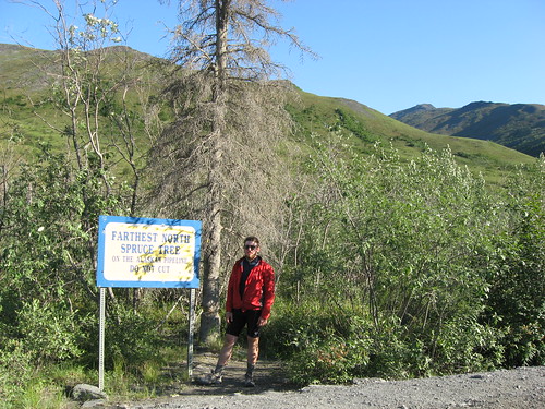
I got off the bike at the furthest north spruce tree and breathed deeply until my legs stopped shaking. Â The lanscape was new, there were trees! Â The sign would say that it is not the cold or the soil further north that preventrs trees from growing, but rather the lack of sunlight.
About 15 miles more and I would find a campsite on the side of a creek.
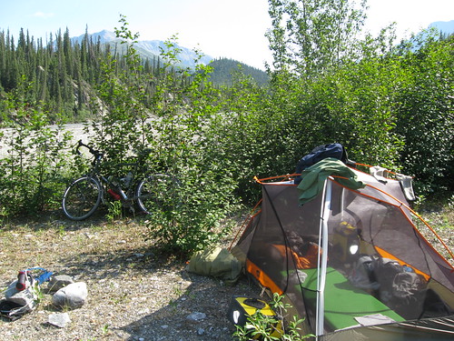
Though the sun didn’t set that night, the 100 hour day was over. I celebrated with a wash in the creek, which was very difficult with the hordes of mosquitoes. Â Thus ends the first chapter. Â Come back for the next installment which will get me to Fairbanks.

Recent Comments